rivers.run 2.0
Continue to app
Free Version
Publisher Description

Water levels and other paddling information at your fingertips! Rivers.run includes information on over 12,000 destinations in the US and Canada.
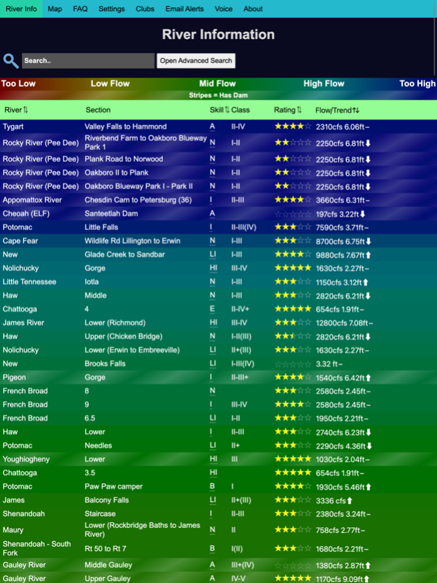
Rivers.run provides water levels, water temperature, and other information, using data collected from over 12,000 gauges. It matches this information with crowdsourced paddling expertise to tell you what a river height actually means, and to provide skill level estimates.
You can use GPS coordinates to find rivers near you, and search rivers by water levels, skill, name, and rating, as well as user provided tags and dam releases, helping you find whitewater (or flatwater) rivers that you want to paddle.
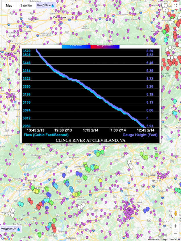
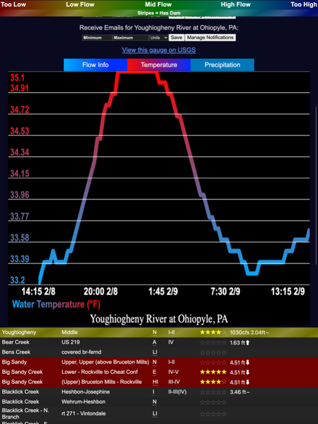
You can also use rivers.run maps to find rivers in an area, and to assist with navigation. Clicking on any point shows all the information rivers.run has about the river - flow, temperature, and other information. If you're interested in weather, you can also enable the weather view to get a good idea of where rain is currently falling.
River flow levels are currently sourced from USGS (United States Geological Survey), NWS (National Weather Service), and the Meterological Service of Canada. Additional sources for gauges are planned for the future.
Information on rivers.run is crowdsourced - so if your favorite river is not available, is missing information on runnable levels, or has other issues, you can help improve it. Just go to the FAQ page in app to find directions on how to get started. If you need any assistance, you can send an email to support@rivers.run.
NOTE: Rivers.run does work offline, however needs to connect at least once in order to download river information. Attempting to use rivers.run offline before it has downloaded information may result in a launch screen freeze. The data being downloaded is ~1MB in size, and highly compressed.
Mar 28, 2022
Version 2.0
Cross-Device Favorites Syncing with Accounts
7 days of data for USGS gauges
50x performance improvement to graph rendering
Fixes to graph scrubbing alignment inside maps
Current GPS location marker in maps
Multiple access points
Complete writeupmaker overhaul
Minor bug fixes to relative flow value estimations
Other bug fixes and performance improvements
About rivers.run
rivers.run is a free app for iOS published in the Astronomy list of apps, part of Home & Hobby.
The company that develops rivers.run is Tucker Willenborg. The latest version released by its developer is 2.0.
To install rivers.run on your iOS device, just click the green Continue To App button above to start the installation process. The app is listed on our website since 2022-03-28 and was downloaded 1 times. We have already checked if the download link is safe, however for your own protection we recommend that you scan the downloaded app with your antivirus. Your antivirus may detect the rivers.run as malware if the download link is broken.
How to install rivers.run on your iOS device:
- Click on the Continue To App button on our website. This will redirect you to the App Store.
- Once the rivers.run is shown in the iTunes listing of your iOS device, you can start its download and installation. Tap on the GET button to the right of the app to start downloading it.
- If you are not logged-in the iOS appstore app, you'll be prompted for your your Apple ID and/or password.
- After rivers.run is downloaded, you'll see an INSTALL button to the right. Tap on it to start the actual installation of the iOS app.
- Once installation is finished you can tap on the OPEN button to start it. Its icon will also be added to your device home screen.
